Location
 Get there      Deutsch
Walking Tours at
LAC CLEUSON
Pictures 
English      Information 

The first hike, which is described below, takes you uphill from Siviez to the dam of Lake Cleuson and via Ouché back to Siviez again. Estimate 1:30 hours walking time on the narrow street from Siviez to the top of the dam. To walk back from the chapel at the dam takes another 1:00 hour. Reserve about 2:45 hours for the whole walking round tour.

Starting from the dam the second hike, which is additional to the first one, will take you around Lake Cleuson (de-scribed far below). However the very narrow mountain foot path alongside the left shore of the lake is suitable only for experienced mountain hikers.

Hike Siviez - Barrage de Cleuson - Ouché - Siviez

© Mister Flaggy / Switzerland shot taken: 03.07.2004 CD:401433/000_00a/20040712

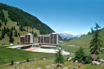
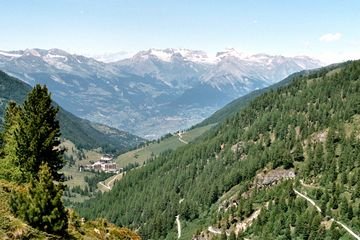
The sticking holiday appartements in Siviez with a view through the valley towards the Bernese Alps. On the right the narrow street to Lac Cleuson is recognizable. In the forground the still young brook "La Printse" flows towards River Rhone.


We start the hike at the end of the car park on the right bank of the brook La Printse right at the valley station of the Chairlift Novelli and follow the narrow, still asphalted road upwards along the valley. After a few hundred metres a picknick area is reached with some stone grills, which may be used as a real alternative to the restaurants for lunch, especially for families with kids.

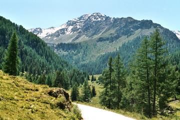
The slowly but steady ascending drive way takes the hiker through colourful yet sap green meadows and thin stock of mixed trees containing different deciduous and needle trees uphill. Flowers with red, yellow, white and lila colour-ed petals make the eye jump from one to the other blos-som like a butterfly. After about 1:15 hours walking time - including taking a short rest - the foot of the dam is eventually reached.

Who does not want to walk up to the top of the dam, may leave the drive way here towards the west and take the foot path which leads directly towards Ouché. Tired wanderers wait here for their comrades, who do want march further up to the lake (it takes about 30 minutes on foot to reach the crest of the dam and to return back to the foot of the wall). Behind the stone building in front of the dam a narrow and very steep foot path along the wall takes you zigzag-wise uphill. For a more relaxed manner uphill continue the hike on the drive way. Through two short tunnels and one more hairpin bend the top of the dam is reached in a further short 15 minutes.

© Mister Flaggy / Switzerland shot taken: 03.07.2004 CD:401433/001_01a/20040712

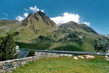
View up the valley towards the mountain ranges Bec des Etagnes und Les Lués as well as the dam in the gap of the valley. Above the two needle trees on the right the mountain teeth of L'Arpette [2'396m] are clearly recognizable.


© Mister Flaggy / Switzerland shot taken: 03.07.2004 CD:401433/010_10a/20040712

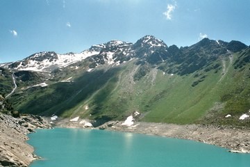
Above the lake in the background rises the ridge of the 3'232 metres high mountain Bec des Etagnes. The nameless peaks of the rock formation on the right of the picture are the southern part of the mountain range Les Lués.


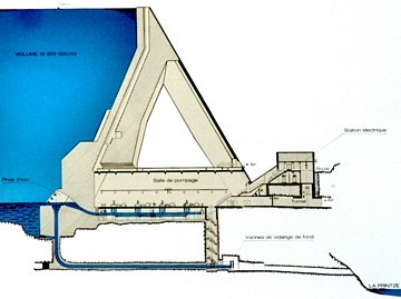
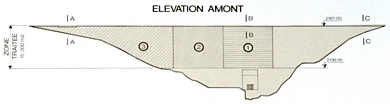
Der Lac Cleuson liegt eng eingebettet in einem Talkessel. Auf der westlichen Seeseite erheben sich die Spitzen der Bergkette Les Lués mit Höhen von 2'577 bzw 2'696 Metern über Meer, welche mit dem 2'462 Meter hohen L'Arpette ihren nördlichen Abschluss finden. Östlich der Staumauer erhebt sich über der Alp Cleuson der Gipfel des Le Perron, mit 2'885 Metern über Meer der höchste Gipfel in unmittelbarer Nachbarschaft des Stausees.
© Mister Flaggy / Switzerland shot taken: 03.07.2004 CD:401433/012_12a/20040712

Blick talauswärts von der Staumauer des Lac Cleuson auf Siviez, das Rhonetal und die Berner Alpen. Im Vordergrund rechts windet sich das Fahrsträsschen bergauf zur Barrage de Cleuson.


Von der Staumauer bietet sich ein schöner Blick talauswärts durch das Val de Nendaz auf Siviez und die Berge auf der an-deren Seite des Rhonetales, welche den Kanton Wallis mit dem Kanton Bern verbinden. Taleinwärts sind über den smaragdgrünen Wassern des Sees die Schneeberge sicht-bar, welche das Wasser für den Bach La Printse liefern, welcher wiederum die verschiedenen Bissses von Veyson-naz über Nendaz bis Saxon speisst, von welchen die Bisse  de Saxon mit mehr als 35km die Längste ist. Die meisten dieser Suonen sind heute noch in Betrieb.

Von der Kapelle Saint Barthélémy folgen wir den gelben Markierungen und überqueren den Überlauf des Stausees, um über den schmalen, steilen Pfad in 5 Minuten den Fuss der Staumauer zu erreichen. Durch lichten Lärchenwald marschieren wir zuerst westwärts dann nordwärts den mässig steilen Bergweg hinunter zum kleinen Feuchtgebiet Ouché, welches wir in weiteren etwa 20 Minuten erreich-en. Ab hier folgen wir, uns rechts haltend, dem unbefes-tigten Fahrsträsschen von Tortin nach Siviez hinunter. Entlang diesem Fahrweg wird Siviez in zirka 40 Minuten Fussmarsch erreicht.

© Mister Flaggy / Switzerland shot taken: 03.07.2004 CD:401433/015_15a/20040712

Östlich der Staumauer liegt der Le Perron [2'885m], an dessen Fuss der Verlauf der ehemaligen Bisse de Chervé, der auf über 2'200 Meter höchst gelegenen Suone des La Printse, gut sichtbar ist.

© Mister Flaggy / Switzerland shot taken: 03.07.2004 CD:401433/013_13a/20040712

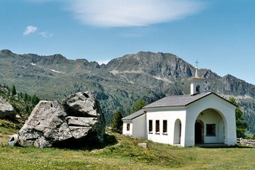
Die Kapelle Saint Barthélémy auf der Westseite der Staumau-er. Über der Kapelle erhebt sich der Mont Gond [2'667m] des-sen Bergrücken sich nach links bis zu den Dents Rousses  [2'619m] fortsetzt.

Location of Lac Cleuson get there | information | pictures | top | back 

Referenced to the kilometer coordinates of the National Maps of Switzerland and the global geodetic datum, some points of interest of the hike may be found at the below listed positions:

  • Parking Siviez, starting point of the hike
  • Barrage de Cleuson, end of the drive way
  • Chapel Saint Barthélémy, west of the dam
590'600 / 110'700
591'140 / 106'860
590'770 / 106'735
E 7° 19' 01.12" / N 46° 08' 51.78"
E 7° 19' 26.54" / N 46° 06' 47.45"
E 7° 19' 09.32" / N 46° 06' 43.38"


Maps of the area: National Map of Switzerland 1:25'000, Sheet 1326 Rosablanche at CHF 13.50 (very recom-mended) or National Map of Switzerland 1:50'000, Sheet 283 Arolla at CHF 13.50. Available is also a Hiking Map 1:50'000, Sheet 283T Arolla at CHF 22.50 (recommended), which shows marked hiking and mountain trails, public transportation with stops and tourist information of the region. Each of the maps is available at the Federal Office of Topography and may be ordered by internet (payment by creditcard: Master and Visa).

Journey to Siviez location | information | pictures | top | back 

Siviez - sometimes also called Super Nendaz - is best reached from Haute-Nendaz by own transportation, since the postal bus service does not run there too often throughout a day. In summer a lot of parking space is always available free of charge. It is about a 7.5 km drive from Nendaz Station (roundabout at post and tourism office) to Siviez.

The short variant of the hike up to the dam - without walking around the lake - can hardly be done by public transport (see timetable) if you don't want to hang around in the restaurants waiting for the postal bus taking you back. The only suitable possibility is offered in the late morning: take the postal bus which departs at Nendaz-Télécabine on 11:10 and arrives at Siviez on 11:28. Then have lunch either before the walking tour in one of the restaurants of Siviez or have a picnic later on the way. The return trip can take place then by the bus departing from Siviez at 15:55 o'clock.

Informations location | get there | pictures | top | back 

© Mister Flaggy / Switzerland Aufnahme: 03.07.2004 CD:401433/007_07a/20040712

Cross section of the dam and the punping station right below the wall. Some electrical equipment is located in the small building in front of the dam (right). The water of the lake is discharged below the dam.

The plan on the right shows a view of the dam of its side towards the water. On the top left side of dam, the spillover is clearly seen. Above the cross section of the dam is shown at the highest part of the dam (B-B).

The Dam. The Dam of Cleuson was built in the years 1947 to 1951. The concrete dam is 87 metres high with a crest length of 420 metres and a dam volume of 400'000 cubic metres. The top of the dam lays on altitude of 2'187 metres above sea level and measures 84.6 metres at the foot of the dam. The dam is constructed as a socalled gravity dam, which has in principle a triangular cross section and whose dead weight alone is sufficient to hold back all the water of the artificial lake.

The Lake. The Lake Cleuson has a length of 1.4 km with a surface of 50'000 square metres. The catchment area of the lake is approximately 26 square kilometres (16.2 km2 in the area of Printse, 6.9 km2 in the area of Tortin) and the dam stores a water volume of up to 19.5 million cubic metres. From the pumping station right below the dam the water is pumped into Lac des Dix which is on a 165 metres higher altitude and lays 7 km away (straight line) in the eastern neighbouring valley. © Mister Flaggy / Switzerland Aufnahme: 03.07.2004 CD:401433/008_08a/20040712


www.flaggy.ch
GOWEBCounter by INLINE
This webpage will be displayed correctly by the internetexplorer Copyright © 2004 by
Mister Flaggy / Switzerland
This webpage is in line with the standard HTML 4.01 Transitional Startpage Nendaz
Disclaimer
This webpage was designed for a screen resolution of 800×600 pixels last modified
14-Aug-2004